
Finding New Haven Residents Along a Street
A street-by-street search works best as a fixed sequence. First normalize the address, then identify the parcel, owner, and municipal custodian. After that, move to the deed or map index, the current voter route, and the historical directory shelf. The goal is not to collect every name. The goal is to answer one bounded question, such as who was recorded with a parcel, which transfers shaped a lot, or which names appeared at an address in a certain year.
- Write the street number, directional prefix or suffix, street type, unit, town, ZIP, and any former name exactly as known.
- Open the New Haven VGSI assessor search or the relevant town's parcel system and record parcel ID, MBLU, situs, mailing address, and assessment date.
- Use the GIS parcel map to inspect the target polygon, buildings, street centerline, and nearby parcel IDs.
- Check the municipal clerk's deed, mortgage, lien, or map index, then preserve the instrument number or book and page reference.
- Use the SOTS voter lookup for a named person and town, not as a street browser.
- For an older address, compare the directory name section with the reverse address section, newspapers, maps, census, probate, or vital records.
That chain keeps an owner, a recorded party, a voter, and a historical resident from being treated as the same field. When a search crosses a town line, restart at the new municipal custodian.
Normalize a New Haven Street Address
Address normalization is the first research step, not clerical cleanup. Record the street number, direction, street type, unit, municipality, ZIP, current parcel ID, and the spelling used in the source. New Haven's nine-square plan and its borders with Hamden, East Haven, West Haven, and Woodbridge can make a road look continuous while the legal town changes. A postal city can also differ from the municipal situs.
Connecticut addresses are assigned locally. New Haven Engineering assigns addresses for new construction, while DESPP's 911 GIS layer supplies street centerlines, address points, and tax-parcel points. The research did not locate a confirmed countywide street renumbering or renaming year. Keep an old number, modern number, parcel ID, map or instrument reference, cross streets, and municipality as separate fields until a deed or map proves the join.
- Situs address
- The physical location attached to a parcel or building in an assessor or GIS record.
- Mailing address
- The address used for notices or owner correspondence, which may be outside the parcel's town.
- Parcel
- A mapped property unit with local identifiers such as parcel ID or MBLU.
- Plat
- A recorded map or plan that shows lots, lines, streets, or subdivisions.
Note: Preserve the source spelling before creating a normalized search spelling, especially when an old map or directory is involved.
Open New Haven's VGSI Street Search
The New Haven VGSI search is the strongest current address tool inspected for this street directory. Its visible modes are Address, Owner, Acct#, MBLU, PID, and All. MBLU can be entered through map, block, and lot components. The page also exposes a Street Listing, Sales Search, and Map route, although the complete sales filters were not captured. There is no visible county selector and no visible ZIP field. All means all available New Haven modes, not all of New Haven County.
The New Haven assessor search screen supplies the source for the capture below.
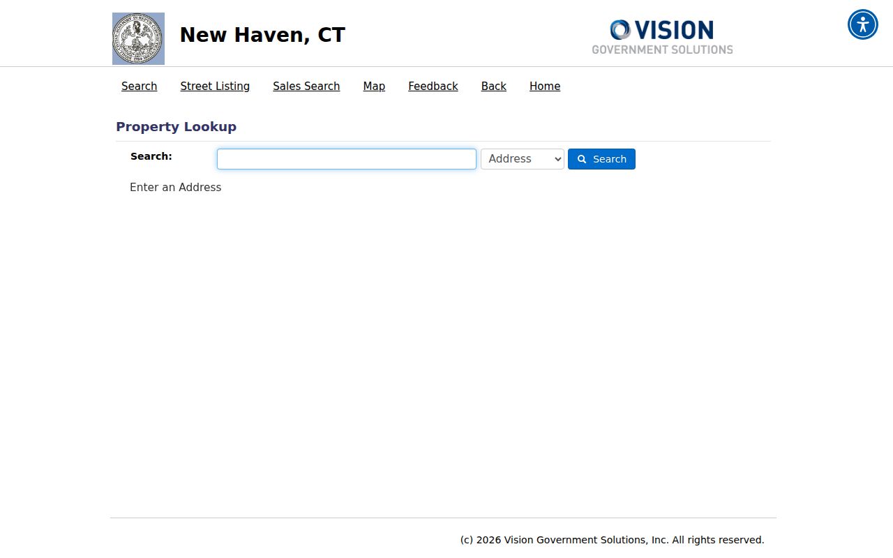
The screen's Address, Owner, Acct#, MBLU, PID, and All modes make the parcel a bridge between a street clue and a municipal record.
| Search mode | Use on a street search |
|---|---|
| Address | Start with the current number and street name. |
| Owner | Test a name, then compare the returned situs and mailing fields. |
| Acct# | Repeat a known municipal account search. |
| MBLU | Use map, block, and lot components when a number is unclear. |
| PID | Carry a parcel identifier into map or assessor checks. |
| All | Run the municipal search across the visible modes. |
The assessor describes October 1 as the assessment date and identifies a 2021 revaluation, 70% assessment level, and 2026 revaluation work. Values are reference data, not a legal description. Record the displayed update or assessment date so a future reader knows what the street directory result meant at the time.
Separate New Haven Situs, Mailing, Parcel
A New Haven street directory fails when a mailing field is silently promoted to occupancy. The assessor card may list a person, trust, company, or representative as owner and show a different mailing location. The situs field is the parcel's physical address. The parcel ID and MBLU link the record to a mapped unit. Those fields establish the shape of a property record, not a list of everyone who uses the building.
Use OPM's Parcel and CAMA metadata to understand the broader GIS layer. It distinguishes standard parcels, condo main and unit records, mobile homes, rights-of-way, water, and suppressed data. Councils of Governments collect digital parcel and CAMA data, while OPM republishes the local material without correcting every field. A blank owner or mailing value can reflect suppression or incomplete data, not an empty parcel.
The Connecticut Parcel and CAMA guidance is the source for the statewide context.
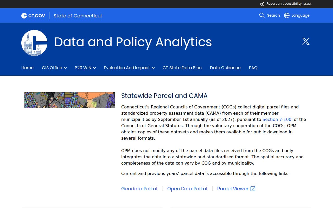
The statewide metadata view supports a careful reading of parcel fields without turning a GIS layer into certified title or a household roll.
New Haven Street Records by Address
Address-keyed records in New Haven have different custodians and different meanings. The table is a street directory coverage map. It shows where to go next and what a result can support, not a promise that every source will name a person.
| Record Set | Keeper | What It Shows | Access |
|---|---|---|---|
| Assessor and Grand List | Municipal assessor | Owner, situs and mailing clues, parcel, assessment, exemptions, sales | VGSI, GIS, assessor office |
| GIS parcel map | New Haven GIS, VGSI, OPM or COG layer | Buildings, streets, polygons, city boundary, parcel fields | Free map or REST query |
| Deeds, liens, and maps | Municipal town or city clerk | Grantor, grantee, instrument, legal description, prior reference | SearchIQS, RecordHub, office copy |
| Permits and certificates | Building Inspection and Enforcement | Applicant, owner, work, inspection, certificate or code clue | Electronic route, office, FOI |
| Property court search | Connecticut Judicial Branch | Party, docket, property case, status, notice | Free summary with date limits |
| Historical directories | NHFPL, libraries, archives | Names at an address, household and business context | In-library, scans, request service |
The parcel ID joins current map and assessor data. The deed's legal description joins transfers. The directory's street or reverse entry joins a historical year. A current voter lookup can corroborate a named town connection, but it is not a walkable street list. Keep the joins visible in the notes.
Map New Haven Street Parcels and Buildings
The New Haven VGSI ArcGIS service exposes City Boundary, Buildings, Parcels, and Streets layers. The parcel schema includes parcel ID, account number, owner-related fields, MBLU components, geometry, area, and length. Query, identify, distance, JSON, and GeoJSON operations are available in the service. These are verified layer features, not a claim that every field is filled on every parcel card.
The New Haven property map service is the source for this street directory image.
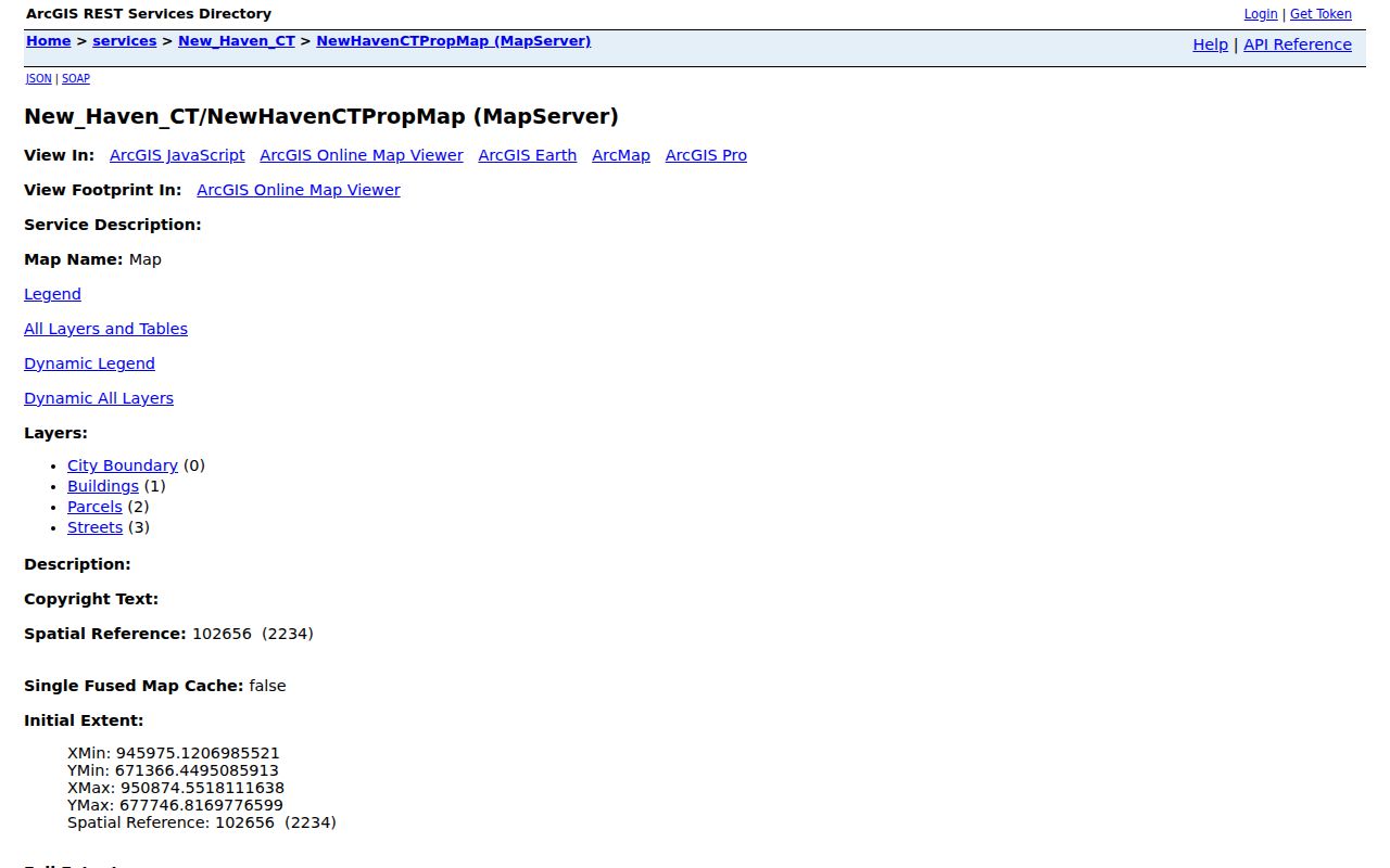
The layer list shows why a street search should capture the target parcel and its geometry before moving to names or transfer records.
DESPP's 911 GIS page adds statewide address points and street centerlines. New Haven Engineering says a deed is the best source for easements. When a GIS point and a legal description disagree, preserve both and ask the municipal office which operational address is current.
Search New Haven Street Deeds and Maps
New Haven SearchIQS is the confirmed city land-record route. Its help material describes land index and images from approximately July 26, 1951 to the present, while a vendor PDF gives August 18, 1952 as the start. Maps are listed from January 1, 1835. Report the land range as 1951 or 1952 to present and confirm the boundary with the clerk. SearchIQS also lists trade-name coverage with different index and image periods.
The public guest gate was visible, but the direct search form was blocked by Cloudflare during the research capture. Do not invent the exact field order or image-payment path. When the live form works, preserve the street index or grantor and grantee terms, instrument type, date, book and page or instrument number, result reference, and image status. For a certified copy, use the municipal clerk.
Other towns use local clerks and vendors. RecordHub is observed for several New Haven County towns, but each town's coverage and fee schedule must be checked. North Branford's official page gives one example of images from June 1, 1975 and local copy and certification charges. It is a comparison point, not a New Haven fee rule.
Note: An index is a finding aid, an image is a reproduction, and a certified copy is the clerk's official product.
Ask for Older New Haven Address Permits
New Haven's building office accepts electronic permit work for current projects, but older permits and certificates may be offline. The researched office route describes scanning and walk-in research on Tuesday and Thursday from noon to 2 p.m. It also says phone research is not the path for these files. A public result screen and exact filters were not captured, so a street directory should not promise a live permit database.
For an older address, ask the Building Inspection and Enforcement office for existing nonexempt permits, certificates of occupancy, inspection notices, and parcel-linked code records. Name the address or parcel, date span, record type, preferred format, and certification need. If the office does not maintain the file online, ask about inspection, scanning, or a Connecticut FOI request to the actual custodian.
A permit can connect an address to an applicant, owner, contractor, architect, work description, or inspection date. It does not list every person who used the building. Compare the permit with the assessor card, deed, map, and historical directory entry.
Use New Haven Property Records Search
The Judicial Branch property-address search is a useful second route because it begins with a town and street rather than a name. It accepts a city or town, optional street address, an optional five-digit ZIP, property type, case status, and case type. The city or town requires at least three characters. Property and foreclosure coverage is date-limited, with most foreclosures searchable from January 1, 2014 and New Haven matters in selected categories beginning later.
The Judicial property-address search supplies the source for the field capture below.
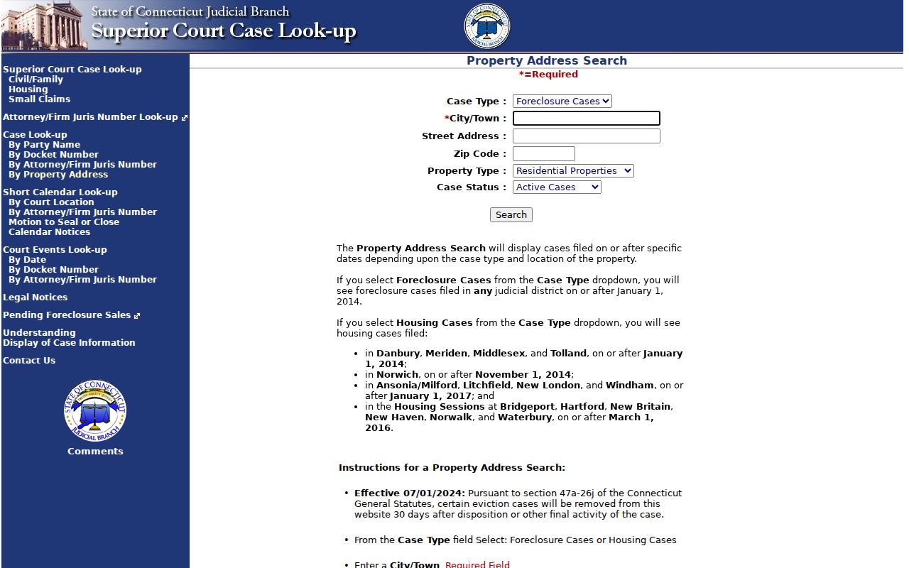
The field set puts city, street, ZIP, property type, and case status beside each other, which makes it useful for a bounded property question.
| Field | Visible rule |
|---|---|
| City or Town | Required; at least three characters, with partial town text allowed. |
| Street Address | Optional; a partial number or street can narrow the search. |
| ZIP Code | Optional; exactly five digits when supplied. |
| Property Type | Residential Properties, Commercial Properties, or All Properties. |
| Case Status | Active Cases, Disposed Cases, or All Cases. |
A court result shows a case connection, not a full ownership history or household list. Complete files, certified copies, older documents, and protected material follow the clerk or courthouse route.
Read Old New Haven Streets Backward
New Haven directories turn a street into names only when the right annual volume and section are used. Search the name section first when a person is known. Then check the reverse address section, which appears from about the 1920s in the NHFPL run, to see other names connected with the address. Compare nearby years, because a number may change, a lot may split, a building may disappear, and directory conventions may omit parts of a household.
Yale's historical map index covers New Haven from 1824 through a 1995 aerial photograph. Sanborn coverage includes 1886, 1901, 1923-24, a 1923-1951 set, and 1973. These sheets can test a footprint, street alignment, lot line, or industrial use when a modern number does not fit. The historical shelf is handled in depth on the New Haven directory book page.
For a modern one-person question, the trail changes to the New Haven resident lookup workflow. Street work should remain focused on address keys and the record chain along a named road.
What New Haven Street Directory Cannot Show
No public source inspected provides a complete list of everyone who uses a New Haven building. An assessor identifies an owner or parcel. A deed identifies recorded parties. A voter record is a named town registration with privacy rules. A directory may list a head of household and omit others. A permit names people tied to a project. DMV data is restricted under the federal Driver's Privacy Protection Act, and utility customer records were not located as a public street source.
Neighbors across a public road are not necessarily adjacent parcels. A right-of-way, water feature, condominium structure, or municipal line can change the relation. The GIS polygon and legal description should decide whether a parcel is beside, behind, across, or merely near another parcel.
Lawful personal use. New Haven address records are suitable for family history, property research, civic questions, and other lawful personal purposes. Do not use a street directory to stalk, harass, intimidate, or harm anyone. A missing or protected address must remain private.
When the online result is blocked, use the municipal office, mail or phone contact, in-person inspection, FOI request, regional parcel layer, library, or archive route documented for that record. State the source date and the uncertainty. That is the difference between a careful New Haven street directory and an unsupported name list.